Nepal is a small country with huge variety. In a north-south distance of roughly 150 to 240 kilometres, the land rises from the plains of the Terai to the highest mountains on Earth. That variety shapes climate, farming, culture and where people live.
Figures here are rounded or "around" values, and measurements get revised (the height of Mount Everest was re-announced jointly by Nepal and China in 2020). For an exam answer, confirm exact numbers in a current official source.
1. Three regions, running east to west
Nepal is usually divided into three ecological belts that run roughly east-west and sit side by side from south to north. The cross-section below shows how the land rises.
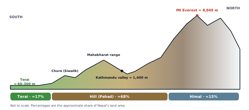
Figure: a simplified south-to-north cross-section of Nepal (not to scale).
2. The three regions compared
| Terai | Hill (Pahad) | Himal (Mountain) | |
|---|---|---|---|
| Position | South, along the Indian border | Middle, between Terai and Himal | North, along the Tibetan border |
| Approx. share of land | Around 17% | Around 68% | Around 15% |
| Height | Roughly 60 to 300 m, up to the lower hills | Roughly 600 m to 3,000 m | Above roughly 4,000 m |
| Climate | Hot and humid, subtropical | Mild, temperate | Cold, alpine to arctic |
| Known for | Fertile farmland, forests, wildlife parks | Kathmandu valley, Pokhara, terraced fields | Eight-thousanders, glaciers, trekking |
The Chure (Siwalik) range lies between the Terai and the Mahabharat range, with inner Terai valleys such as Chitwan in between.
3. Mountains
Eight of the world's fourteen peaks above 8,000 metres lie fully or partly in Nepal. They include Mount Everest, Kanchenjunga, Lhotse, Makalu, Cho Oyu, Dhaulagiri, Manaslu and Annapurna I. Everest, the highest, is about 8,849 metres.
4. Rivers
Nepal's rivers fall into three groups by origin:
- Snow-fed rivers from the Himal that flow all year: the Koshi (eastern), Gandaki / Narayani (central) and Karnali (western) river systems, plus the Mahakali on the western border.
- Rivers from the Mahabharat range that depend on rain and spring water, such as the Kamala and Bagmati.
- Rivers from the Chure range, which are seasonal and often dry in winter.
These rivers flow south into India and join the Ganga. They give Nepal huge hydropower potential, though only part of it has been developed.
5. Lakes and wetlands
Well-known lakes include Phewa, Begnas and Rupa in the Pokhara valley, Rara (often noted as the largest lake) in the north-west, and the high-altitude Gosaikunda. Nepal also has internationally listed wetlands.
6. Climate and seasons
Nepal has four commonly described seasons: spring, summer (including the monsoon, when most rain falls), autumn and winter. Altitude matters more than latitude: it can be hot in the Terai and snowing in the Himal on the same day.
7. Protected areas
Nepal has national parks, wildlife reserves and conservation areas. Chitwan was the first national park (1973), and Sagarmatha National Park protects the Everest region. Both are listed as World Heritage Sites.
Quick facts to revise
- Landlocked, bordered by India and China (Tibet).
- Total area is roughly 147,000 square kilometres.
- Lowest point is in the eastern Terai (around 60 metres); highest is Mount Everest.
- Seven provinces and 77 districts.
Use a map while studying, and practise geography MCQs often, because places and numbers are easier to recall when you can picture them.


Comments
Loading comments…